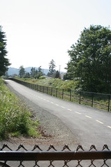
A pictorial journey along the E & N Rail Trail

The E & N Rail Trail, boldly promised to be finished by “the 2010 Olympics” just a few years ago by the CRD (PDF), is now finally taking shape in Langford. I thought I would bike out there and see how it measured up.

For starters, this little section of the trail is tiny. Much like the Bowker Creek Greenway in Browning Park I talked about, network effects mean that both trails will get few users until such time as more of them are completed.
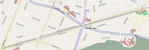
E & N Rail Trail Map. Map data: OpenStreetMap/OpenCycleMap

Starting for the westernmost side on Atkins Road, the trail starts with a very old pedestrian bridge over the trail, which was created for the students of Savory Elementary School. On the other side of the bridge you are dumped into the school yard about 50m from the actual start to the trail.
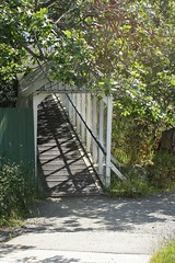
The old pedestrian bridge]
The old pedestrian bridge
Looking west at the start of the trail
Mural, with parking to the right

The trail itself is straight and fairly flat, although immediately the potential for conflicts with the adjacent parking lots became apparent. Why the CRD/City of Langford didn’t choose to at least bollard off this I don’t know. As it is, it is far too easy to drive onto not only this section of trail but also one other section west of Phipps Road.
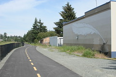
Mural, with parking to the right
Murals, with parking to the right

After crossing Veteran’s Memorial Parkway at Goldstream you wonder where the trail went. I really hope this is a temporary thing (there were construction signs everywhere along the trail stating it wasn’t open yet) because you can see just how bad it is.
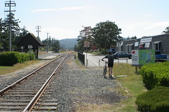
East of Veteran's Memorial Parkway, the connection to the trail is sadly lacking.

At the other end of this section, the section between the sidewalk and the trail is likewise unfinished. But that isn’t the worse part about the Peatt Road crossing. For some unknown reason, rather than just crossing in parallel with the rail line, you are forced to travel south to the intersection, cross Peatt there, then along the sidewalk, cross back over rail line (as of yet unfinished) and to the trail. Utterly ridiculous.
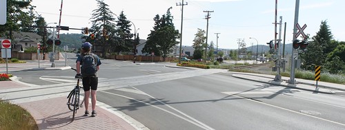
The Peatt Road crossing

The other end of the trail (and current westernmost end) just dumps you out onto the sidewalk. No indication where you could go next for another trail, etc. I realize that the trail’s costs ballooned, but still. A simple sign directing you back to the Galloping Goose would have been nice. At least it has a connection to the road.
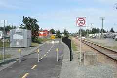
Westernmost end of the trail

And thus we finish this section of the E&N Rail Trail. It is a great start but there are a few head-scratching decisions here and there. Hopefully these can be fixed but it is better to get it right the first time. Let’s hope the CRD and their member municipalities open up the design phase a bit earlier so that these mistakes can be caught and corrected before they are concrete (literally). To see larger versions of these pictures (and a few others) see my flickr set.

Transit sucks for seniors, so let’s have less of it

Sometimes you have to look at the bigger picture to see the absurdity of it all. The Times Colonist has a pair of stories today, both talking about long running issues that are plaguing our region. The first covers the loss of driver’s licenses by and how the choices left suck. Then we have an article saying that the City of Victoria may not run rail across any new and/or refurbished Johnson St. Bridge. Right, so we need better transit options but we should reduce those options by not running rail transit across the bridge. And despite what some commenters are saying, it is not about 300m of track. Once there is something useful running on those tracks, there will be pressure to extend the tracks, possibly to link into any light rail coming down Douglas St. Bah.

Malahat crash shows need for better rail

Budd Car on Blue Bridge. Neither likely to be replaced anytime soon. Photo Credit Mick Hall

The Malahat crash that killed at least one person is merely the latest in example of why we need to fix the rail link up the island. Imagine if this accident has involved one of the dozens of trucks carrying dangerous chemicals and gases up and down the island? The consequence are pretty horrible to think of. And as we approach winter, we are again reminded that the Malahat is one of the few places on the island that regularly gets snow and ice during the coldest parts of year, merely adding to the danger.

Thankfully the solutions are actually pretty cheap. Just rebuilding the track bed would allow expanded freight service and a modest investment in new passenger vehicles would make passenger trips much faster and more pleasant. None of these things have a huge price tag. The Island Corridor Foundation, a consortium of Native bands, municipalities and others, who own the trackbed and land have estimated the cost at a mere $30 million to rebuild the entire corridor to modern standards. This is just a little bit more than the cost of either the stalled Spencer’s Road or new McTavish Road interchanges. As for passenger service, the Ottawa O-Train pioneered the use of time separation to allow running of lighter trains on the shared lines. (There are some arcane North American rules about crash ratings for passenger trains running on mixed tracks, something Europe is not burdened with). The O-Train uses Bombardier’s Talent diesel trains (usually known as DMU, or Diesel-multi-units), which were tacked onto a German purchase. For more money numbers and and some interesting background info, I suggest Transport Canada’s case study of the O-Train.

Are we likely to see any of this in the near future? Well, BC Transit is busy spending that money it was given by the province to study rapid transit in the CRD and scuttlebutt says that at least some portion of the E&N factors into those plans. As for the larger corridor itself, the Cowichan Valley Commuter might spur some interest on the northern side of the Malahat. However, I am not holding my breath.